Multiple target areas with extensive gold soil anomalies, high-grade intercepts, conducive structures and significant eluvial gold and artisanal mining activity.
Highlights
- The 100km2 Bido Licence is located in the prolific Poura Birimian greenstone belt, Burkina Faso
- Multiple gold prospects across the Licence area including extensive historical artisanal workings
- Recently obtained historic data revealing high-grade gold drill intercepts at the Kwademen prospect including 23m @ 1.53g/t Au
Location
The 100km2 Bido Licence is located in Burkina Faso, approximately 150km West South West of the capital Ouagadougou. The Licence is within the prolific Poura Birimian greenstone belt that hosts multiple >1 million ounces (“Moz”) gold deposits including Konkera (3.3Moz), Gaoua (3.4Moz), and Poura (1Moz), as shown in Figure 1. Also, a significant base metal deposit, Perkoa (5.5Mt @ 12% Zn), is located approximately 30 km north of the project area.
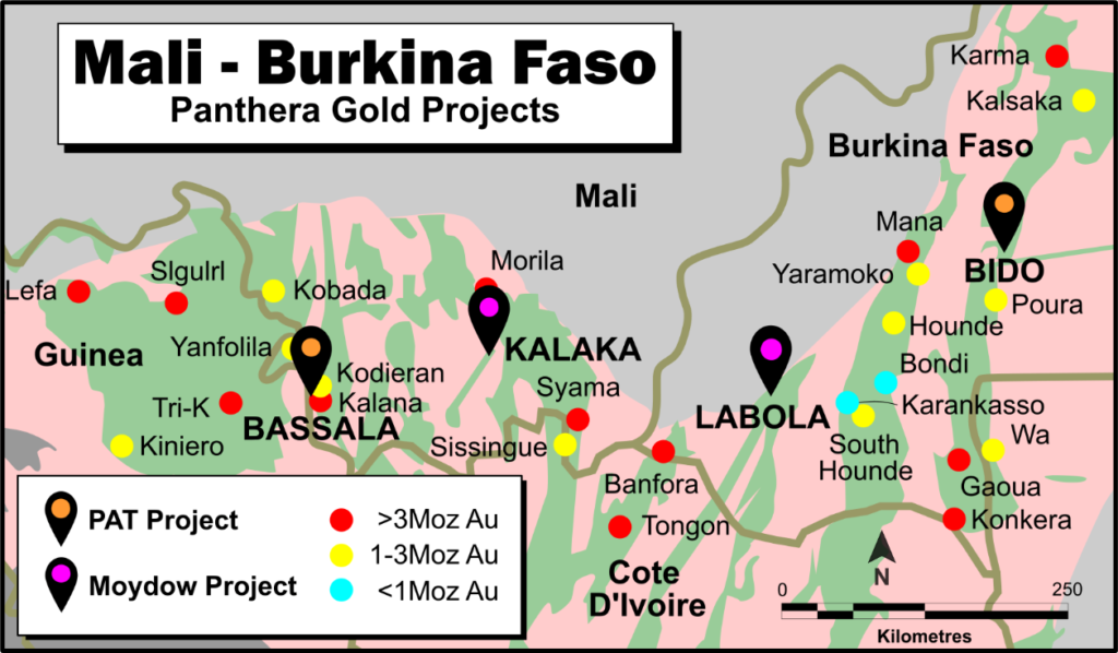
Figure 1: Project Location (Source: IGL)
Bido Project History
Canadian junior exploration company, Carlin Resource Corporation (“CRC”) and Sahel Gold Mines (“SGM”), on behalf of a private Canadian company, explored the tenement from 1996 to 2014. During this time, soil sampling, trenching and mapping of old gold workings was completed. CRC tested 7 targets with 40 RC holes for a total of 2,836m of drilling. SGM focussed in the far northwest of the area at the well-known Kwademen Prospect, which has a number of ancient workings. SGM completed soil sampling, trenching, Rotary Air Blast (RAB) drilling (1,005m in 23 holes) and diamond drilling (539m in 5 holes). Soil sampling has been carried out over approximately 30% of the project tenement. Samples have been collected on a nominal 200m x 200m grid with infill sampling to 100m by 100m in places. There appears to have been no significant work undertaken since 2014 other than IGL’s due diligence activities. Source: GA CPR 2017
Bido Geology
Although the Bido project is an early stage exploration project, it does present strong indicators of mineralisation. All known orogenic gold deposits in Burkina Faso are hosted in Birimian Greenstones and approximately 75% of the tenement consists of such gelogy as shown in Figure 4. The geology of the tenement is a mix of volcano-sedimentary rocks composed of amphibolised mafics in the west and east, volcano-sedimentary schist in the southwest, schist and quartzite in the northwest, and a gabbro on the southern boundary. All are viable exploration targets.
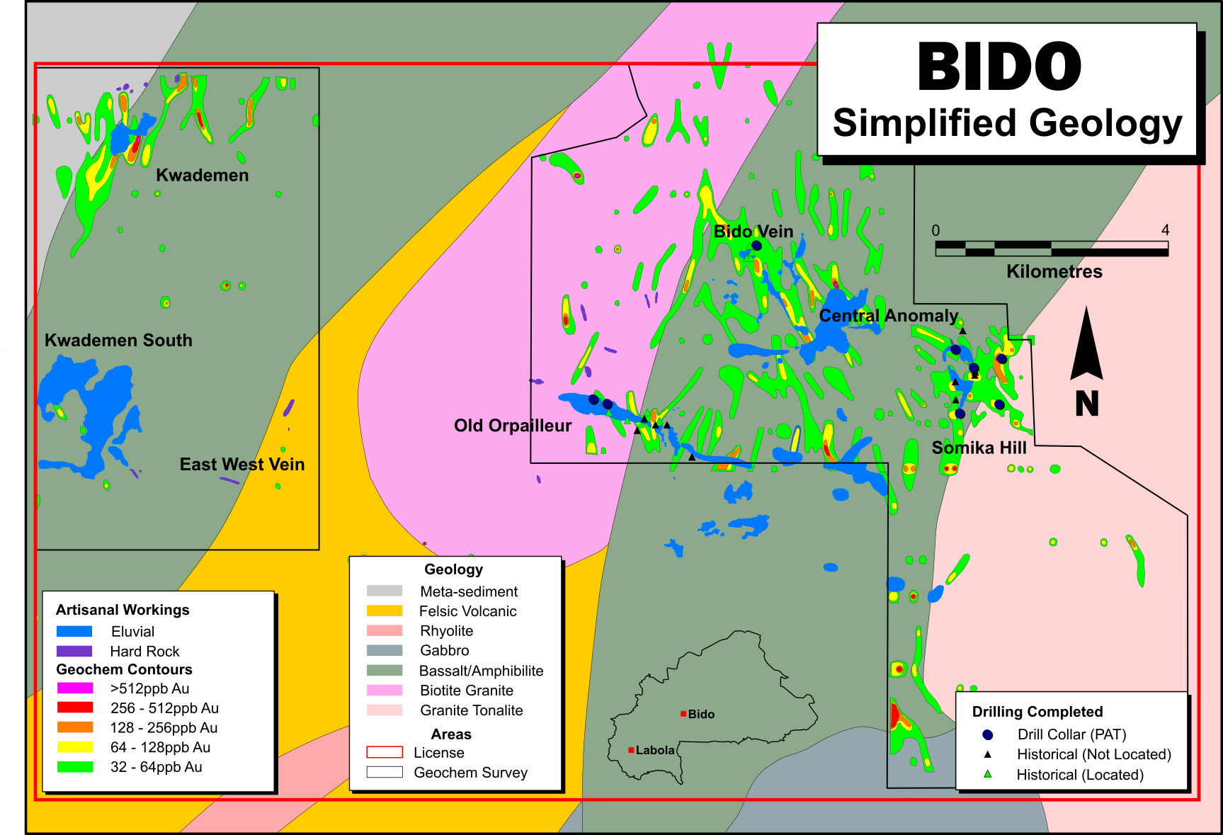
Figure 2: Geological map of the Bido Project (Source: IGL)
Somika Hill Prospect
As detailed in the Company’s announcement dated 14 January 2018, subsequent work conducted by Panthera has to date concentrated on the east of the Licence. This work culminated in a first pass drilling programme that returned several positive gold intercepts including 8m @ 4.78g/t Au from 66m in drill hole PSHRC004 at the Kaga Vein prospect at the Somika Hill Prospect (Figure 3).
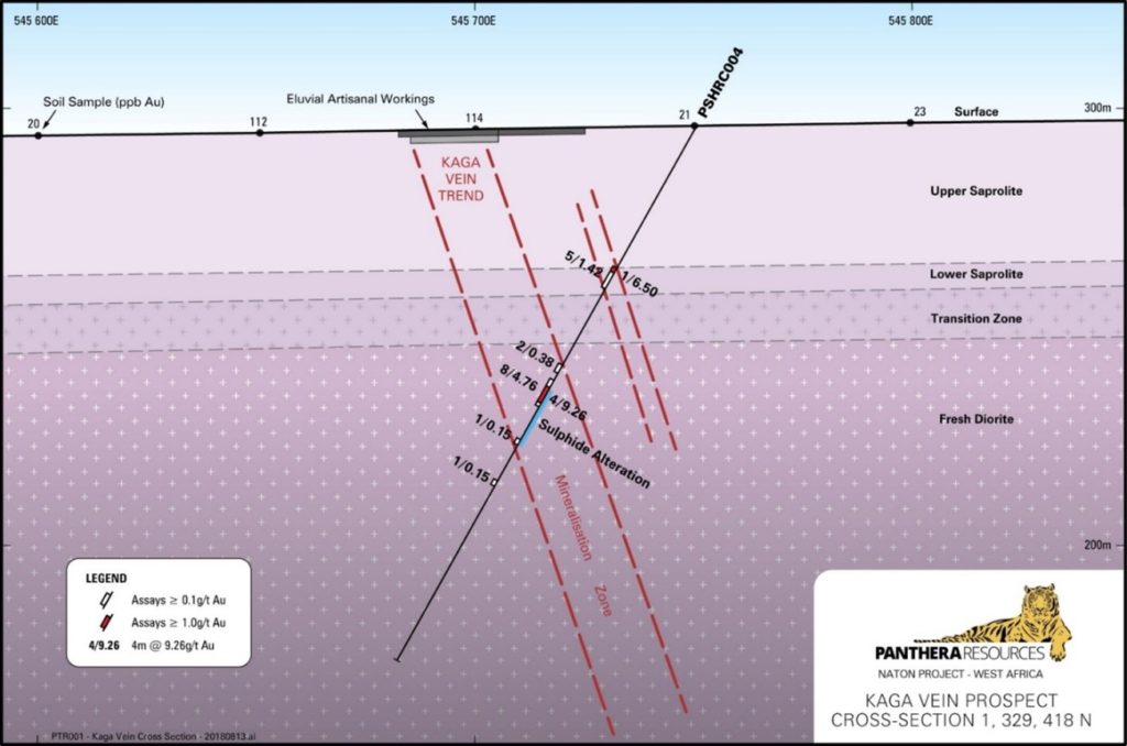
Figure 3: Kaga Vein Drilling Cross -Section (Source: IGL)
Kwademen Prospect
More recently, additional data has been obtained from the BUMIGEB work that was conducted in the western part of the tenement during 1980-81 at the Kwademen Prospect. This returned several encouraging gold intercepts in broadly spaced drilling (~200m to 300m line spacing) including:
- 16m @ 1.07g/t Au from 69m
- 10.4m @ 2.14g/t Au from 191m
- 23m @ 1.53g/t Au from 143m
- 2.25m @ 7.74g/t Au from 155.8m
- 1.45m @ 16.0g/t Au from 52m
- 1m @ 40.0g/t Au from 90m
Soil sampling conducted by Panthera over the last two years has shown that this drilling is located to the west of the main gold in soil anomaly and also west of the area of artisanal mining activity (Figure 4). The main part of the gold in soil geochemical anomaly and associated artisanal gold mining activity can thus be seen to represent a highly prospective ‘walk-up’ drill target, with over 1,000m of strike potential.
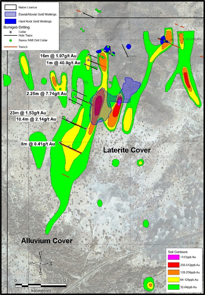
Figure 4: Kwademen Soil Sampling, Artisanal Gold Workings, and Previous Drilling
Kwademen South
Another zone of artisanal gold mining activity is located to the south of Kwademen, possibly associated with a fault offset continuation of the main Kwademen mineralisation (Figure 5).
This large area of workings (>1.5km strike) is focused beneath a laterite hardpan (Figure 6) which masks the soil geochemical signature of underlying mineralisation and hence the mineralisation does not show up as a soil geochemical anomaly. These laterites show up as high total count areas in the regional radiometric data (red/yellow background on Figure 5) and this can be used to map the areas where soil geochemistry is unlikely to be effective.
Notwithstanding the absence of a gold in soil geochemical anomaly, the very extensive artisanal mining activity beneath the laterite hardpan (Figures 5 and 6) suggests that this area also represents an excellent gold target not previously drill tested.
The Kwademen and Kwademen South targets are both considered to be very high priority targets and will be assessed as part of the planned drilling programme and geophysical analysis.
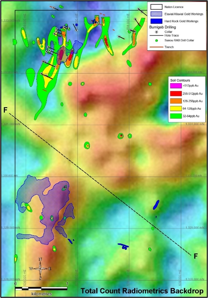
Figure 5: Kwademen South Artisanal Gold Workings and Interpreted Fault
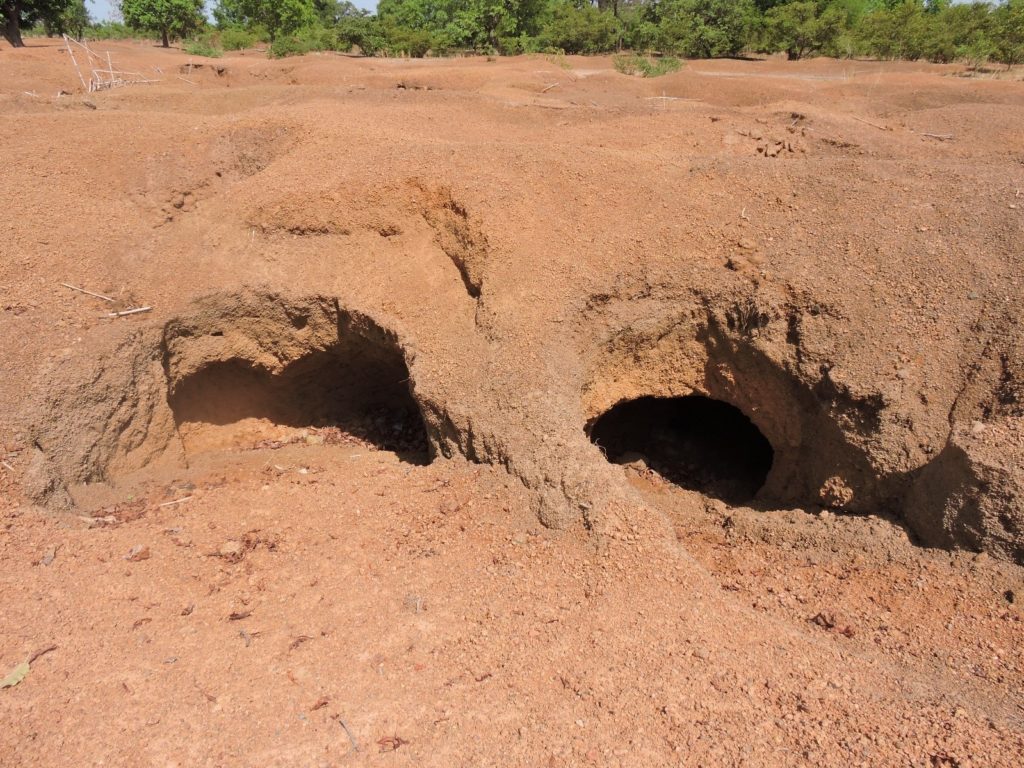
Figure 6: Artisanal Gold Workings Targeting Beneath Laterite Hardpan at Kwademen South

Burkina Faso at a glance
Main economic sectors:
Cotton lint, beverages, agricultural processing, soap, cigarettes, textiles, gold