World class asset targeting 6.0Moz+ resource. Primary mineralisation from near-surface with potential to develop into a large, bulk mineable open-pit operation JORC-compliant resources of 1.74Moz, with a planning exploration programme to increase this to a target in excess of 6.0Moz.
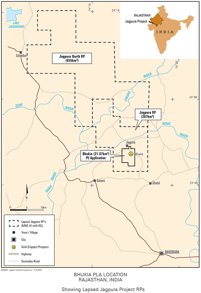
The Bhukia Project consists of a PL application that lies within the former Jagpura Reconnaissance Permit Tenement. The two previous Reconnaissance Permits (RP) were called Jagpura and Jagpura North. The Company selected the smaller Bhukia area, for which the PL application has been submitted. It’s selection was based on results from exploration work conducted on the larger RP areas and followed from detailed negotiations with the Rajasthan Department of Mines and Geology (DMG).
Bhukia Project History
The Bhukia Project sits within an area that has clear evidence of ancient diggings and panning. During the 1970s and 1980s; the Geological Survey of India (“GSI”) and the Rajasthan DMG drill tested the ancient workings during a regional copper exploration programme. No gold analyses were undertaken during this work. The GSI noted visible signs of gold during field assessments in the early 1990s. Further testing confirmed significant gold mineralisation at Bhukia as well as surrounding locations. In 1993, Hindustan Zinc Limited (HZL) applied for, and was granted a PL, completing 4,000.3m of shallow diamond drilling which resulted in an unclassified resource of 8.7 Mt at 2.0g/t Au. Initially the focus of HZL was to see if there was the potential for mining the oxidised mineralisation processing via heap leach. The trial was not successful and the findings by HZL led the company to let the licence lapse in 2001.
Figure 1: Location of Bhukia application in relation to previously granted (but expired) RPs

Following incorporation of the IGMPL joint venture with MMI in 2005, IGMPL carried out reconnaissance over the 207km2 Jagpura area, following which a series of PL applications were submitted culminating in the current PL application over an area of 21.07km2. The area is referred to as the Bhukia Project. IGMPL drilled 21 holes during the term of the RP and defined a JORC (2012) compliant resource of 1.74 million ounces in two zones. The GSI had been exploring the area intermittently since 1992, in part under a departmental reservation for the purpose, and subsequent to IGMPL’s reconnaissance work and PL application. The GSI completed a total of 42,942m drilling via 155 drill holes up until the cessation of its activities in the area at the end of 2014. The GSI reported resources for multiple blocks (zones) within the Bhukia PL application area. Although the resources are substantial, the GSI work does not comply with JORC guidelines and cannot be reported in any official resource statement, nor used for economic evaluation of the property, but does provide an informed indication as to potential size and scale of the deposit. The drilling has shown gold mineralisation cross-cuts all lithologies and most alteration packages and the locations of the ore zones within the delineated deposit.
Bhukia Mineral Resource Estimate
Mineral Resources classified in compliance with the JORC 2012 and reported at a 0.5 g/t Au cut-off grade.
| Zone | Category | Gross | Net Attributable | Operator | ||||
| Tonnes (Mt) | Grade | Gold | Tonnes (Mt) | Grade | Gold | |||
| (g/t Au) | (koz.) | (g/t Au) | (koz.) | |||||
| Mahi | Inferred | 24.1 | 1.3 | 1,010 | 16.8 | 1.3 | 707 | IGMPL |
| Panch Mahuri | Inferred | 14.4 | 1.6 | 730 | 10.0 | 1.6 | 511 | IGMPL |
| Total | 38.5 | 1.4 | 1,740 | 26.9 | 1.4 | 1,218 | ||
Table 1 : Mineral Resource Estimate for Bhukia Project
Bhukia Geology
Detailed geological mapping has been completed at Bhukia, concluding that the local geology is complex with at least three generations of folding and lithologies demonstrating variable intensities of alteration. See Figure 2 for a simplified geological map. In the east of the mapped area, exposed bedrock is generally micaceous schist, mostly overlain by shallow alluvial cover. The schist unit contacts with a carbonate and clastic sediment sequence to the west, at a major almost north-south trending shear zone that appears to be parallel to the local hills. The major structure is locally known as the Ghatol Shear. The shear dips at 50-60 degrees to the west and hosts significant mineralisation. Dolomite or dolomitic marble underlays much of the PL application area. Varying quantities of calc‑silicate and albitic lenses are layered within it. The dolomite is iron rich (ankeritic) in areas, which appears to be the product of alteration and may be useful as a pathfinder to further mineralisation. This unit hosts significant mineralisation at Panch Mahuri, Delwara and Timran Mata, which all lie within the Bhukia PL application area. The calc-silicate unit is well mineralised in the eastern part of the area. The calc-silicates in the west of the map area are often finely banded and weakly mineralised.

India at a glance
Main economic sectors:
Textiles, Chemicals, Food Processing, Steel, Transportation, Cement, Mining, Petroleum, Machinery, Software, Pharmaceuticals